|

|
|
With the Flow Report for the Week of May 22 - May 28, 2023River flows, floods, spills and boil advisories by watershed region
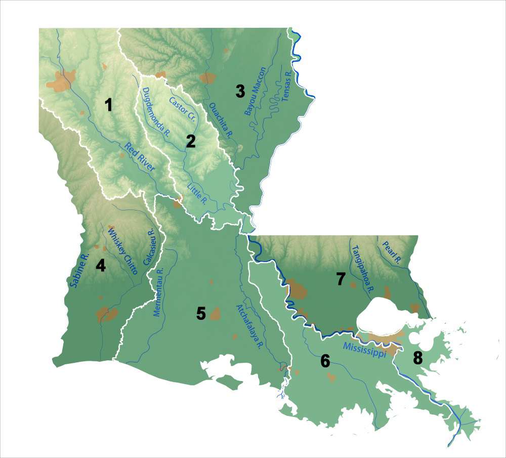
Find your location in one of the eight watershed regions of Louisiana here:
Table updated May 26 2:45 pm CDT
The Red River collects rainfall and runoff from 57,000 square miles of northern Texas, Oklahoma and Arkansas before entering Louisiana’s Caddo Parish. The Red River and tributaries gather runoff from Caddo Parish, Bossier Parish, Webster Parish, the west half of Claiborne Parish, Red River Parish, DeSoto Parish, Nachitoches Parish, the east edge of Sabine Parish, the south half of Winn Parish, the west half of Grant Parish and the northwest corner of Rapides Parish. Water Bodies include Caddo Lake, Nantachie Lake, Cypress Lake, Bodcau Lake, Swan Lake, Half Moon Lake, Lake Ninock Flows Red River drains an area of 57,000 sq miles of Arkansas, Texas and Oklahoma before entering LA’s Caddo Parish. Red River continues south through LA, draining the bounded area known as LA Watershed Region 1.
Flat River drains an area of 949 sq miles of Bossier Parish. The flow
Black Bayou drains an area of 177 sq miles of Caddo Parish. The flow at Rodessa is unrated, we have reported it at 12 ft deep. (updated 04-18-23) Paw Paw Bayou drains an area of 80 sq miles in Parish. Normal flow near Greenwood is around 30 cfs and 3.8 ft deep. (updated 04-18-23) Bodcau Bayou drains an area of 410 sq miles of Arkansas before entering Caddo Parish. The flow is monitored
Bayou Dorcheat drains an area of 605 sq miles in Webster Parish. The flow
Twelvemile Bayou drains 3137 sq miles of Caddo Parish. The flow near Dixie is unrated, 23 ft deep is common (updated 03/21/23) Cypress Bayou Lake receives drainage from an area of 163 sq miles in Caddo Parish. The flow
Saline Bayou drains an area of 154 sq miles of Bienville Parish. Normal flow near Lucky is around 170 cfs and up to 5.6 ft deep. (updated 03/21/23) Red Chute Bayou drains an area of 980 sq miles in Bossier Parish. Normal flow
Caddo Lake receives the drainage for 2744 sq miles in Caddo County.
Bayou Pierre drains an area of 879 sq miles in Caddo Parish. The flow
Cross Bayou at Hwy 80 west of Greenwood, 2.5 ft deep (03/21/23) McCain Creek near Blanchard, 2.7 ft deep (updated 03/21/23) Nantachie Lake, Nantachie Creek reservoir draining 80 square miles of Grant Parish, flowing southeast to join the Red River. Flow near Aloha is unrated, 14.5 ft deep (03/21/23) High Flows (0), Floods (0) Drinking Water Advisories (1) April 25 – Haughton (Bossier) - Boil Water Advisory issued by the Town of Haughton effective immediately for residents from Big Red Circle to Freedom. Date of Occurrence: 4-27-23. Citizens are encouraged to bring water to a rolling boil for three minutes before using. Spills (0)
The Dugdemona River and its tributaries drain Region 2 down to Catahoula Lake, joining the Red River as it heads down to the Gulf. The northern mid-line of Region 2 features includes flows into the Caney Creek Reservoir on the west side of the drainage basin with Little River taking flows on the eastern side of the basin. Region 2 includes the southern part of Lincoln Parish, the east side of Bienville Parish, most of Jackson Parish, the majority of Winn Parish to its eastern border, the west half of Caldwell Parish, the east half of Grant Parish, all of Lasalle Parish, most of Catahoula Parish to the south border, all but the northwest corner of Rapides Parish, and the north part of Avoyelles Parish. Flood sensitive areas in this drainage basin include the southwest quarter of Hodge, the east side of Jordan Hill, the centre and east side of Deville, centre of Pineville, the south of Centre Point. Parts of Rapides Parish and the majority of Avoyelles Parish are extremely vulnerable to overland flooding. Water bodies include Catahoula Lake, Caney Creek Reservoir. Dugdemona River drains an area of 740 sq miles in Jackson Parish. Normal flow
Little River drains an area of 1899 sq miles of Caldwell and LaSalle Parishes. The flow
Big Creek drains an area of 51 sq miles of the east side of Grant Parish. Normal flow at Pollock is 50 cfs and 3 ft deep, (updated 03/21/23) Floods (0) Drinking Water Advisories (1) April 13 – Kelly (Caldwell) Boil Water Advisory issued by Kelly Water District for the following customers: Avenue C, Hwy 843, Hwy 165, White Rd., Burlington Rd., Madison Dr., Washer Rd., Bass Rd., Miller Rd., Emma Ln., Hawkins Dr., Magnolia Ln., Carr Dr., Hargrove Lane due to a 6 inch main water line break. Spills (0)
The Tensas River originates in East Carroll Parish flowing in and out of Lake Providence in northeast Louisiana. The Tensas drainage basin begins in Arkansas just south of Little Rock and widens out in Louisiana to drain East Carroll Parish, Madison Parish and Tensas Parish on the east side of Region 3. Ouachita River drains central portion of Region 3, Corney Bayou and tributaries draining the west side. Flows Tensas River drains an area of 957 sq miles of Tensas Parish. Normal flows
Bayou Macon drains an area of 782 square miles in Richland Parish. Normal flows
Bayou Bartholemew drains an area of 1190 sq miles in Morehouse Parish. The flow
Boeuf River drains an area of 1226 square miles of Richland Parish. The flow
Ouachita River drains an area of 15298 sq miles of Ouachita Parish. The flow
Little Corney Bayou drains an area of 208 sq miles of Union Parish. Normal flow near Lillie (USGS 07366200) is around 200 cfs and 5.4 ft deep (updated 03/21/23) Bayou Lafourche drains an area of 361 sq miles in Richland Parish. Normal flows
Bayou Darbonne drains an area of 1607 sq miles in Union Parish. Normal flow at the Lake at Dam near Downsville is unrated, we have seen it measured at over 40 ft deep (flood stage 83 ft). (updated 03/21/23) High Flows (0) Floods (0) Drinking Water Advisories (6) May 18 - D’Arbonne (Union) Boil Water Advisory issued by the D’Arbonne Water North for customers in Union Parish due to a break in the water main and loss of water. The advisory concentrates on the following locations: Charles Road, So. Caledonia Road, Mt. Moriah Church Road, 2545 to 4322 E. Stateline Road, Rashia Road, 80 Mike Taylor Road, Hall Pratt Road May 18 - Central Claiborne Water System (Claiborne) - A boil advisory has been issued by Central Claiborne Water System for some customers in Claiborne Parish due to suspected contamination of the water supply. The water has, or could have, germs that can make you sick. People on the who live in the following areas are urged to boil their water before using it: White Oak Rd, White Oak Cut Off, Ruple Rd from White Oak Rd to Camp Rd, Slaughter Rd and Hwy 79. May 15 – River Road Water Works (Richland)- Boil Water Advisory issued by the River Road Water Works for some customers in Richland Parish including: Pony Greer Road, Pipes Greer Road, Blaylock Road, Bee Bayou Road south of I-20. May 10 – Bastrop (Morehouse) Boil Water Advisory issued by Waterworks No. 1 water system for customers on Mer Rouge Road including Timber’s Trailer Park heading west on Mer Rouge Road, north onto Peach Orchard Road to 9950 Peach Orchard Road. This advisory will continue until further notice. Apr 25 - Columbia (Caldwell) Boil Water Advisory issued by the East Columbia Water System for customers on Rodeo Road, Highway 133, Bellview Lane Highway 4 from Highway 133 and the remaining portion of the system going south. April 11 – Monticello (East Carroll) Boil Water Advisory issued by Monticello Water System due to a water main break. This boil advisory covers the Monticello and Epps area. Spills (4)
Draining the western half of DeSoto Parish, all but the eastern-most sliver of Sabine Parish, all of Vernon Parish, the west slice of Rapides Parish, all of Beauregard Parish and the west half of Allen Parish, the vast majority of Calcasieu Parish (the east bit is found in Region 5), the northwest corner of Jefferson Davis Parish and the west half of Cameron Parish. Bayou Toro drains an area of 148 sq miles in Sabine Parish. Normal flow at Toro is 190 cfs and 5.5 ft deep; (updated 03/21/23) Bayou Anacoco drains an area of 365 sq miles in Vernon Parish. Normal flow near Rosepine is 800 cfs and 7.5 ft deep. (updated 03/21/23) Sabine River drains an area of sq miles in Parish. The flow
Bundick Creek drains an area of 120 sq miles of Beauregard Parish. The flow
Calcasieu River drains an area of 1700 square miles of Rapides Parish and Allen Parish. The flow
High Flows (0) Floods (0) Drinking Water Advisories (2) May 17 - Lake Charles (Calcasieu), Smith Village Mobile Home Park and Fairview South Mobile Home Park - Boil advisories have been issued for Smiths Village and Fairview South Mobile Home Park. Both are due to a main water line break. April 21 - Oakdale (Allen) Boil Water Advisory issued for City of Oakdale. City officials say the water storage tanks in Oakdale are so old, the tops are caving in and could possibly be exposed to the elements. The city says it is working with engineers and the state and is nearing completion of the installation of a new water storage tank. Residents are under a boil advisory until further notice, expect a few weeks. Spills (1)
Draining a large part of Rapides Parish (centre), the south two-thirds of Avoyelles Parish, the west side slice of Pointe Coupee Parish, the eastern-most slice of Allen Parish, all of Evangeline, all of St. Landry, all of Acadia Parishes, the southeast corner of Calcasieu Parish, the majority of Jefferson Davis Parish (south), all of Lafayette Parish, all of St. Martin Parish, the western-most slice of Iberville Parish, the majority of Cameron Parish (east) all of Vermillion Parish, all if not most of Iberia Parish, most of St. Mary Parish. Here the Mississippi River clears the Old River Works dropping down 22 feet to meet the flow of the Red River, combining to reach one million cubic feet per second flow volume. From here we have a new river, called Atchafalaya. This legendary flow deposits sediment from the central plains over the final 150 miles to the Gulf of Mexico. Flows Red River flows into Avoyelles Parish where the Old Man River lock distracts the Mississippi river into the Atchafalaya River. USGS WaterWatch does not display monitoring stations on the lower portion of the Red River. Bayou Cocodrie drains an area of 240 square miles of Rapides Parish. The flow at Clearwater is above normal, 151.50% above mean at 1030 cfs and 16.39 ft deep. (updated 02/17/23) Bayou Vermillion drains an area of square miles in Lafayette Parish. The flow
Bayou des Glaises Diversion Channel drains an area of sq miles in 284 sq miles in Avoyelles Parish. The flow
Bayou Courtableu drains an area of 715 square miles of St. Landry Parish. The flow
Atchafalaya River officially begins at Simmesport, Louisiana, taking in the combined drainage flows from the Red River and Mississippi River, 87570 square miles.
(updated 04-05-23) High Flows (0) Floods (0) Drinking Water Advisories (4) May 15 – Opelousas (St Landry) - A boil advisory is in effect for some Opelousas residents due to emergency water repairs. The water department crew is currently on site according to officials. The following streets are under the boil advisory: Honeysuckle Lane, Courtyard Street, Cottage Street, Gallery Street, Lakewood Street. May 9 - Church Point (Acadia) – Boil Water Advisory issued by Mire Branch Water Corporation due to water service disruption. Water has been shut off for customers on Gayle Drive, Eddie Lane, and St. Romain Lane to repair a water line. May 1 - Ville Platte (Evangeline) – Boil Water Advisory issued by Reddell Vidrine Water District's due to issues with water supply. The problems began after an overnight electrical issue occurred in the treatment plant, officials say. The boil order will remain in effect until rescinded by the water system upon notification from the Louisiana Department of Health. April 17 - Elton (Jefferson Davis) Boil Water Advisory issued for the town of Elton following water valve repairs completed on April 14. Following restoration of service customers will be under boil advisory until further notice. Spills (3)
Region 6 Draining parts of Pointe Coupee Parish (centre), West Baton Rouge Parish, Iberville Parish, a tiny corner of Iberia Parish (southeast), a wee slice of west Ascension Parish, all of Assumption Parish, the south parts of St. James and St. John the Baptist Parishes, the eastern-most parts of St. Martin and St. Mary Parishes, all of Terrebonne Parish, all of Lafourche Parish, the south half of St. Charles Parish, the south part of Jefferson Parish, the west side of Plaquemines Parish and a tiny corner of Orleans Parish. Flows Lower Atchafalaya River
Bayou Grand Caillou drains an area of Terrebonne Parish. The flow at
Bayou Boeuf flow at Railroad Bridge at Amelia, flow is unrated, commonly 15000 cfs and can be 2.5 ft deep (updated 04-05-23) Bayou Teche drains an area of 1530 sq miles in St. Martin Parish. The flow
Bayou Lafourche drains an area of Lafourche Parish. The flow at
High Flows (0), Floods (0) Drinking Water Advisories (0) Spills (0) Region 7 Draining parts of West Feliciana, East Feliciana Parishes, all of St. Helena Parish, all of Tangipahoa Parish, all of Washington Parish, all of East Baton Rouge Parish, all of Livingston Parish, all of St. Tammany Parish, part of Iberville, part of Ascension Parish, St. John the Baptist, St. James and St. Charles Parishes. Flows Mississippi River drains an area of 1,125,810 square miles of the USA and parts of Central Canada. The flow
Pearl River drains an area of sq miles in Parish. The flow
Bogue Chitto drains an area of 990 sq miles in Washington Parish. The flow
Tangipahoa River drains an area of 646 sq miles in Tangipahoa Parish. The flow
Natalbany River drains an area of 79.5 sq miles in Tangipahoa Parish. The flow
Tickfaw River drains a 247 sq mile area in Livingston Parish. The flow
Lake Ponchartrain at Crossover 4 near Mandeville, 11 ft deep (updated 04-06-23) Tchefuncte River drains an area of 103 sq miles of St. Tammany Parish. The flow
Comite River drains an area of 284 sq miles of East Feliciana Parish and East Baton Rouge Parish. The flow
Beaver Bayou drains an area in East Baton Rouge Parish. Flow at
Amite River drains an area of 1775 sq miles of East Baton Rouge. The flow
High Flows (0), Floods (0) Drinking Water Advisories (2) May 7 -Tangipahoa (Tangipahoa) – Boil Water Advisory issued by the Village of Tangipahoa. All residents are being advised to boil their water due to a problem at the community well. May 1 - Lake Hills Water System (St. Tammany) - Boil Water Advisory issued by St. Tammany Department of Utilities for the Lake Hills Water System LA 1103128. The water service has been shut off to perform a routine inspection and cleaning of the water storage tank. Out of an abundance of caution and in accordance with Louisiana Department of Health regulations, the entire Lake Hills Water System is under a precautionary boil water advisory. It is recommended that all consumers disinfect their water before consuming it (including fountain drinks), making ice, brushing teeth, or using it for food preparation or rinsing of foods Spills (1)
Region 8
Draining parts of St. Charles, Jefferson, Orleans, Plaquemines and St. Bernard Parishes Water Bodies include Lake Ponchartrain, Rigolets Strait, Lake Borgne Flows Mississippi River drains an area of 1,129,910 sq miles of USA and Central Canada. Flow measured in Region 8
Crooked Bayou (estuary) drains an area of Plaquemines Parish. The flow NW of Lake Cuatro Caballo near Delacroix is unrated, tidal estuary ranges from under a foot to 3 ft, temp and conductance are measured here (updated 04-05-23) Black Bay (estuary) near Stone Island, near Pointe-a-la-Hache is unrated, can be less than a foot deep depending on the tide; temp and conductance are measured here. (updated 04-05-23) Floods (0) Drinking Water Advisories (0) Spills (0)
Report Key: WTLA reports federal, state and regional source data on stream flows, groundwater levels, oil and other hazardous materials spill incidents by watershed, along with reporting hazardous algae blooms, algal toxin alerts at recreational freshwater bodies and in drinking water reservoirs. Information in this report is presented in the watershed area of occurrence, based on the location given by the source. Flows: With The Flow describes Louisiana rivers, bayous and tributaries from headwaters to outlet. Locate your “home body” (the river or bayou nearest where you live) to see where the flow originates, how high it has to be for minor flooding to occur. Log in to USGS Waterwatch current streamflow for real time measurements at the monitoring station nearest you and sign up there for high flow alerts. Flow volume can change rapidly during storms and rain events. Streamflow data is subject to review as sensors at the monitoring stations do malfunction from time to time. Refer to USGS Provisional Date Statement for more information. Groundwater Monitor: USGS Groundwater Watch site has been removed, groundwater test wells are no longer measured and posted. WTGA will bring updates as USGS upgrades their monitoring system. Impaired Water Bodies (IWB) 303d List The Clean Water Act (CWA) Section 303(d) Program provides a mechanism for integration of implementation efforts to restore and protect the nation’s aquatic resources. Through this process the nation’s waters are assessed, restoration and protection objectives are systematically prioritized, and Total Maximum Daily Loads (TMDLs) and alternative approaches are adaptively implemented to achieve water quality goals with collaboration of State and Federal agencies, tribes, the regulated community, and the public. New Vision of the CWA 303(d) Program A new long-term vision for assessment, restoration, and protection under the CWA 303(d) Program for 2016 through 2022 (new vision) has been described whereby states may identify and prioritize watersheds for these restoration and protection efforts under the CWA 303(d) Program. The primary goals of this new vision of the CWA 303(d) Program include prioritization, assessment, protection, alternatives, engagement, and integration. The new vision will guide the realization of our clean water goals in a manner that recognizes lessons learned from the past two decades of CWA 303(d) Program implementation and addresses new challenges with innovative solution. Drinking Water Advisories
Hazardous Algae Blooms (HABs) Beach Alerts Cyanobacteria are commonly referred to as blue-green algae; dense accumulations of toxin-producing cyanobacteria are referred to as “hazardous algae blooms”. Toxins may be present both before and after cyanobacteria are observed. WTLA posts the latest HABs reports around the state in the watersheds where they are occur. Spills Spill Emergency: Call Louisiana State Police 1-225-925-6595 within 1 hour of the spill incident. call LSP HAZ MAT hotline 1-877-925-6595 or 225-925-6595 *The hazardous materials hot line is staffed by the Right-to-Know Unit and is the reporting point to the LSP for a chemical spill or emergency. Any transporter, manufacturer, storage facility, or anyone involving the handling of any regulated hazardous material must contact the LSP immediately to report any spillage or threat to public safety.
National Response Center (NRC) at 1-800-424-8802 24-hour emergency line staffed by US Coast Guard for oil spills on water. An emergency spill situation is defined as any condition that could reasonably be expected to endanger the health and safety of the public or cause significant adverse impact to the environment. For non-emergency spills: Call Louisiana Department of Environmental Quality (DEQ) 24 hour Hotline 1-225-342-1234 Or, SPOC office line 1-225-219-3640 (within 24 hours of the spill, follow up with a written report in 7 days) _DEQ-CustomerServiceCenter@la.gov WTLA gathers data from LA DEQ, LADH, USGS WaterWatch, USGS Groundwater Watch, the National Weather Service, National Oceanographic and Atmospheric Administration (NOAA) sources. Our accuracy is dependent on these sources. End Notes: Louisiana's oil spill rules generally follow the federal standards. Any unauthorized spills of one barrel (42 gallons) of oil or more is considered the reportable amount. These and spills of unknown amount must be reported to DEQ within 24 hours, or in the case of an emergency event, see above, call State Police immediately. All reportable spills (emergency or not) must be followed up within 7 days with a written report. Consult with LA DEQ for guidance on detailing your spill incident, check the national requirements for reporting oil spills, and LA release notification requirements. Seek out information on Spill Prevention Planning. “oil” includes but is not limited to: gasoline, crude oil, fuel oil, diesel oil, lubricating oil, sludge, oil refuse, oil mixed with wastes, and any other petroleum related product. “chemical” spills include all toxic substances, note “Any transporter, manufacturer, storage facility, or anyone involving the handling of any regulated hazardous material must contact the LSP immediately to report any spillage or threat to public safety.” Refer to LA Department of Health Environmental Epidemiology and Toxicology page for more information on reporting (https://ldh.la.gov/page/834) Note that all spills must be cleaned up, whether or not they are reportable. The OEC Surveillance Division protects the citizens of the state by conducting inspections of permitted and non-permitted facilities, by responding to environmental incidents such as unauthorized releases, spills and citizen complaints, natural disasters, and other emergency situations, by providing compliance assistance to the regulated community when appropriate, by assessing and monitoring air and water quality for compliance with standards, and by promoting case information management for vigorous and timely resolution of issues of non-compliance.
|
| WT Canada Mexico USA: New York Georgia Louisiana Ohio California |
|
All rights reserved 2025 - WTLA - This material may not be reproduced in whole or in part and may not be distributed, publicly performed, proxy cached or otherwise used, except with express permission. |